Digital Collections

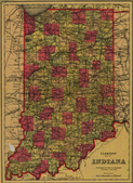
Climate Data: Indianapolis, IN 1940-present

In collaboration with the Indianapolis Public Library, IUPUI University Library digitized a collection of Local Climate Data dating from 1940 to present. The data is recorded from the Indianapolis International Airport (NOAA) and is now available via the web. Also available are several weather related newspaper articles ranging from 1936-1971. Additionally, you can view a dynamic weather calendar to view precipitation and temperature dating back to the late 1800s.

Historic Indiana Atlases

The resources in this collection are historical atlases of various Indiana counties including Hamilton, Henry, Madison and Putnam. These books not only provide maps of Hoosier areas dating from 1875 to 1901, but also provide rich historical details of the central Indiana region. Within this collection there are narrative histories, biographical information about Indiana pioneers, detailed illustrations of people and places, statistical tables, and much more. Historians and hobbyists alike should find this collection both information rich and entertaining.

Historic Indiana Maps

Maps are often beautiful illustrations of our history, the human-environmental interaction, and natural features of our state and its communities. Maps record settlement patterns, political boundaries, transportation routes, and land ownership. Maps contain invaluable information for historians, genealogists, and citizens. The resources in this collection are historical maps of Indiana, its counties and cities, from the collections at Indiana University. Efforts were made to represent various areas of our state, but selection was based on G. K. Hall and Co.'s Checklist of Printed Maps of the Middle West to 1900 Volume 3 covering the state of Indiana.

Historic Indiana Plat Books

The Plat Books of Indiana Counties are historic guides to the communities of Indiana, showing townships, roads and section numbers. These geographic resources were originally created by Sidwell Studio and W. W. Hixson & Co. between approximately 1925 and 1941. Only approximate dates are available as the publisher neglected to date the books. The original books are owned by and scanned in collaboration with the Indiana State Library through a grant from the Library Fund of Indianapolis Foundation, an affiliate of the Central Indiana Community Foundation.

Indianapolis Sanborn Map and Baist Atlas Collection

This collection consists of several large-scale color maps from the late 19th and early to mid-20th centuries, depicting the commercial, industrial, and residential sections of Indianapolis, Indiana. These maps were originally produced for insurance underwriters, who used them to determine risks and establish premiums. Today they are used by scholars and researchers in such fields as history, urban geography, architectural history and preservation, ethnic studies, and urban archaeology.

IUPUI Image Collection

This collection of digital images visually represents IUPUI's history and development as a teaching facility, an academic institution, a continually transforming campus, and a group of ever growing students, faculty, and staff.